Fact Check: False ‘Terrorist Hideout’ Coordinates in Benue Risk Turning Civilians into Targets
A widely shared post on X misidentified a rural civilian settlement in Benue State, Nigeria, as a terrorist base, raising fears of misdirected military action at a time of heightened US-Nigeria security anxiety. Over 400 civilians have been killed in such misdirected attacks.
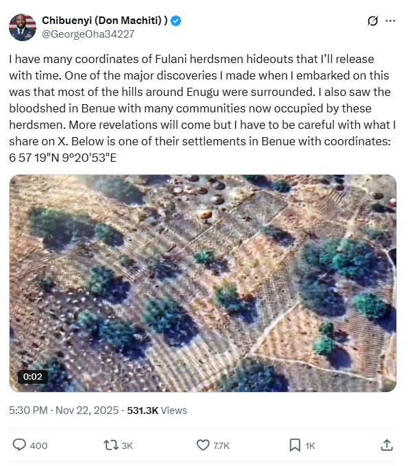
When an X user, who goes by Chibuenyi (Don Machiti), announced that he had obtained “coordinates of [terrorists] hideouts” and published one of them — 6°57′19″ N, 9°20′53″ E — he framed it as part of a broader mission to expose terrorism across Nigeria.
Within 72 hours, the post had been viewed more than 530,000 times, feeding into an already febrile atmosphere of fear, anger, and competing narratives around violence in the country.
But the reality on the ground at the site he identified tells a different story.
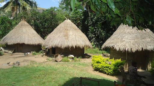
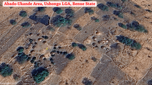
The coordinate points to a small rural settlement in Ushongo Local Government Area, Benue State, in North Central Nigeria. It sits in hilly terrain and consists of more than nine thatched structures. The closest named settlements from the satellite are Abado and Ukande. These communities, too, feature clusters of mud huts, with only a scattering of zinc-roofed houses.
Using Google Earth, the same platform from which the claim originated, HumAngle’s analysis of the location shows clear signs of active farming, including fresh ridges and cultivated plots. Over time, the imagery reflects continuous habitation, with no indicators of displacement, destruction, or military activity. Instead, the land appears to have steadily developed.
In this part of Benue, a cluster of mud huts is not evidence of terrorist presence. It is, rather, the predominant form of housing. Nearby, LGEA Primary School, Ukande, is a well-established landmark and serves as a polling unit during elections in the Ikyov Ward.
We observed at least 30 other active settlements in the vicinity with similar housing styles.
Terngu Tyavkase, a native of the Abado-Ukande area, who also works with the Ushongo LG secretariat, told HumAngle that local farming families occupy the area, adding that the area is not known for hosting pastoralists, who are often blamed for attacks, let alone armed groups.
“We have never had attacks, and every settlement in the area is inhabited by our people,” he said. Terngu’s elder brother was a former chairperson of the LGA, and he is also an active political figure in the locality. “Ikyov is my council ward, and the area you are referring to is my village.”
HumAngle spoke to other natives who expressed shock over such claims of a terrorist’s hideout within their community. “I doubt it is here [Ushongo] the person is talking about. There is no such thing here,” said Bernard Taryuha, another Ushongo native.
Seventeen of the state’s 23 LGAs have been attacked by terrorists at least once, according to the Benue State Emergency Management Agency. Ushongo, the location of the viral coordinate, is one of the six LGAs that have not experienced such violence, even though communities in neighbouring Kwande have faced repeated attacks.
“It is dangerous to share the coordinates of locations without ground verification,” said Mansir Muhammed, HumAngle’s Senior Specialist for GIS, OSINT, and Emerging Tech, who reviewed the satellite imagery. “Geospatial intelligence requires both satellite and human sources. In this case, the coordinates of the location shared are within walking distance of other settlements in this rural landscape. The houses are similar, and the surroundings are also similar, with farms and cultivation fields spreading through the landscape.”
Unlike parts of the North West where armed groups exert control over farming communities — imposing informal levies, restricting access to fields, or demanding localised “peace deals” in exchange for reduced attacks — there is no comparable dynamic in the Abado–Ukande area or elsewhere in Ushongo LGA. Residents continue to farm freely, move without such conditions, and maintain ordinary community routines.
For years, parts of Benue have been beset by episodes of farmer–herder conflict, historically mediated through local dialogue. In recent times, however, several residents and community leaders have argued that the assaults are now unprovoked and cannot be described solely as resource-driven disputes. The state governor, Hyacinth Alia, has publicly referred to the violence as “some form of terrorism”. “It is beyond just conflict or ethnic clashes between herders and farmers; it is directed, planned, and executed,” he said.
These attacks have killed scores and displaced over half a million people, many of whom now live in camps and have remained there for as long as a decade. Recently, HumAngle reviewed satellite imagery of at least 15 deserted communities in Benue’s hardest hit LGAs: Guma, Makurdi, and Gwer West. In each case, we found strong indicators of abandonment: collapsed roofs, disappearing footpaths, and vegetation reclaiming homesteads. None of these patterns appears at the site publicised in the viral X post, where daily life continues uninterrupted.
The stakes surrounding this wrong information are high. Shortly after the United States redesignated Nigeria a “country of particular concern”, US President Donald Trump publicly threatened potential military action against Nigeria over alleged “persecution of Christians”.
“I am hereby instructing our Department of War to prepare for possible action,” he said, adding that if there were to be an attack, it would be “fast, vicious, and sweet”.
The Nigerian government has since expressed willingness to cooperate with the US to protect all residents and also fight the terrorists. Recently, Nigeria’s National Security Advisor, Nuhu Ribadu, met with US Secretary of War, Pete Hegseth, to discuss “ways to make tangible progress on stopping violence against Christians in Nigeria and combating West African jihadist terrorist groups”.
Chibuenyi, the X user behind the viral post, claims affiliation with the US Department of War. HumAngle could not verify this.

However, the viral X post reflects a wider trend of digital vigilantism, where ordinary social media users assume intelligence-gathering roles and publicly share “suspect” information in the belief that they are assisting security forces. In conflict-affected regions, this behaviour often escalates risks: unverified claims spread quickly, armed actors sometimes act on faulty tips, and civilians can become targets of online suspicion or offline harm.
Security analysts note that these dynamics erode formal reporting channels and complicate genuine counterterrorism efforts.
“Sadly, this is what guides the US government and feeds what targets their military will be planning on. The typical rural, or even herding, settlements [are now at risk],” said a retired Nigerian Army brigadier general, who wants to be anonymous. “Anyone can geo-map around Abuja and declare [random] areas as terrorist camps. What are our agencies, who are organised, equipped, and authorised, doing?”
This context makes the circulation of unverified coordinates of civilian settlements during such a sensitive period especially dangerous, particularly if foreign or domestic security actors were to act on them without scrutiny.
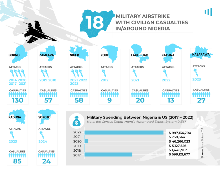
Nigeria’s recent history underscores these dangers. For instance, in 2022, the Nigerian Air Force, working with “intelligence”, bombed Kurebe, a rural civilian community in Niger State, in the country’s North Central, killing six children. Although authorities denied that such an attack occurred, independent investigations revealed otherwise.
This is not the first time. Since 2014, more than 400 civilians have been killed in at least 18 military airstrikes, according to incident reports and public statements. The strikes were intended to target armed groups but instead hit civilian settlements, including during a wedding ceremony. When authorities admit, they typically describe the incidents as “accidental”.
Hence, mislabelled coordinates — particularly those widely circulated online — could place innocent communities in the path of potential aerial operations meant for insurgents.
Map analysis and illustration by Mansir Muhammed.
An X user named Chibuenyi claimed to have exposed terrorist hideouts in Nigeria by announcing coordinates corresponding to a rural settlement in Ushongo, Benue State.
However, an investigation using Google Earth revealed active farming and habitation in the area, contradicting any signs of displacement or military presence. The settlement consists mainly of mud huts, which are common in the region, rather than evidence of terrorism.
Local residents and leaders expressed disbelief at being labeled a terrorist hideout, highlighting that Ushongo has not faced such violence, contrasting with some neighboring areas. Misinformation such as unverified coordinates can escalate risks, causing unnecessary panic and potentially leading to errors in military operations. Historical context shows that similar inaccuracies have tragically resulted in civilian casualties from military actions, underscoring the importance of verified intelligence in conflict regions.
The incident exemplifies challenges posed by digital vigilantism, which can hinder genuine security efforts.
Support Our Journalism
There are millions of ordinary people affected by conflict in Africa whose stories are missing in the mainstream media. HumAngle is determined to tell those challenging and under-reported stories, hoping that the people impacted by these conflicts will find the safety and security they deserve.
To ensure that we continue to provide public service coverage, we have a small favour to ask you. We want you to be part of our journalistic endeavour by contributing a token to us.
Your donation will further promote a robust, free, and independent media.
Donate HereStay Closer To The Stories That Matter