28 States, 102 LGAs More Probable To Witness Flooding In 2020 – Data
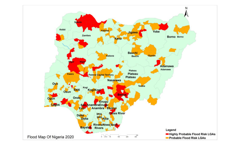
At least 102 local government areas (LGAs) in Nigeria are highly probable to be flooded in 2020.
The local government areas are spread across 28 states in Nigeria, according to data from the Nigeria Hydrological Services Agency (NIHSA)’s 2020 Annual Flood Outlook (AFO).
All states and the Federal Capital Territory (FCT) are expected to experience different levels of flooding during the year, the agency stated.
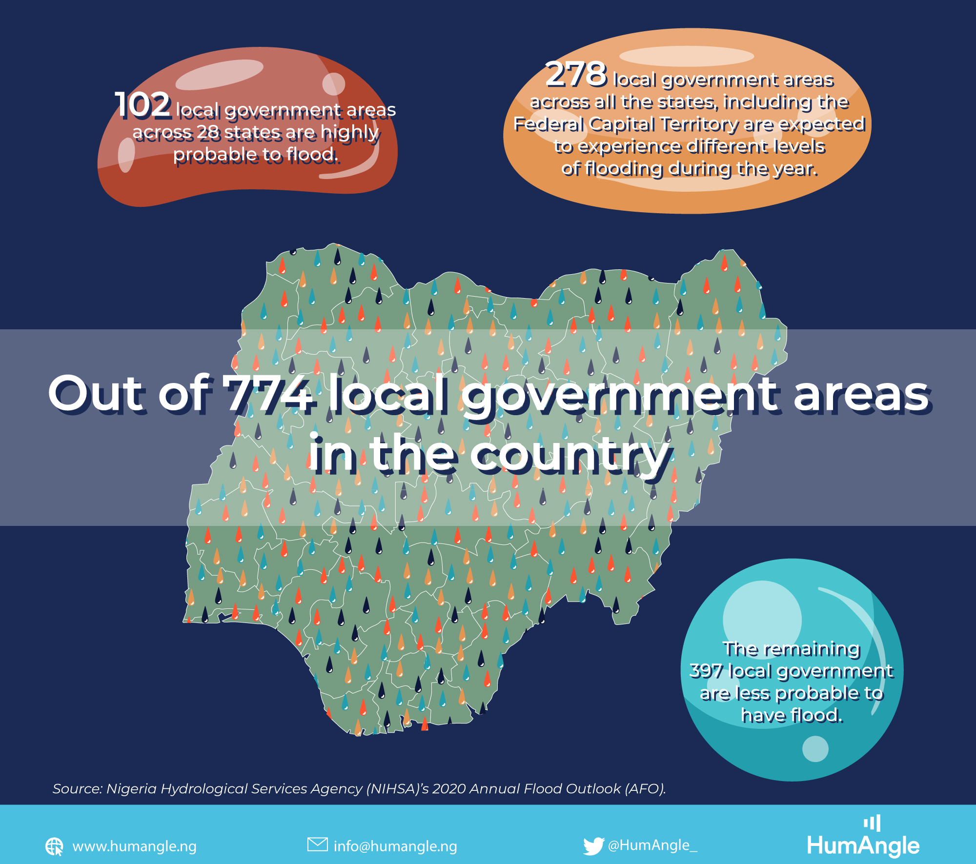
Out of the 774 local government areas in Nigeria, 102 are predicted to be highly probable while 275 local government areas are probable to experience flooding.
Also, 397 LGAs are predicted to be less probable to flood occurrence and
NIHSA advised that people pay attention to all predictions and adhere to advice on how to respond to the situation.
The flood scenarios presented in the AFO are derived from the application of Geospatial Stream Flow Model (GeoSFM) and Soil and Water Assessment Tool (SWAT).
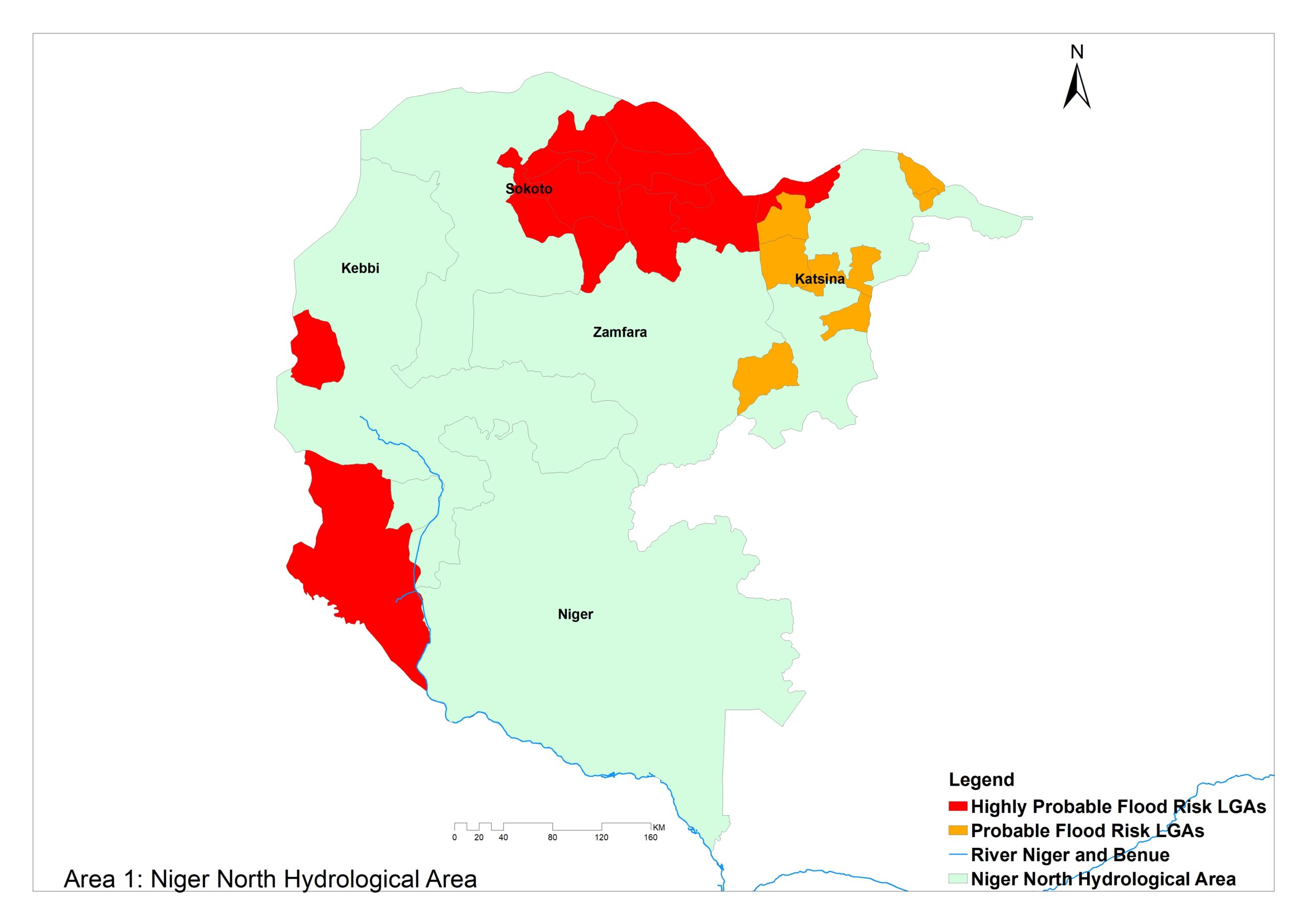
Area 1 (high Risk) – Niger North (River) comprises Kebbi, Zamfara, Sokoto and parts of Niger and Katsina states and it is drained mainly by the Rivers Niger, Sokoto and Rima.
The highly probable flood risk LGAs in this area are Katsina (Jibia), Kebbi (Dandi, Bunza), Niger (Borgu), Sokoto (Goronyo, Sokoto North, Sabon Birni, Rabah, Isa, Sokoto South, Dange-Shumi, kware, Wurno) and Zamfara (Bakura, Maradun, Shinkafi, Zurmi).
The probable flood risk LGAs in the area are Katsina (Kankia, Faskari, Mai’Adua, Musawa, Sandamu, Batsari, Dutsin Ma and Daura).
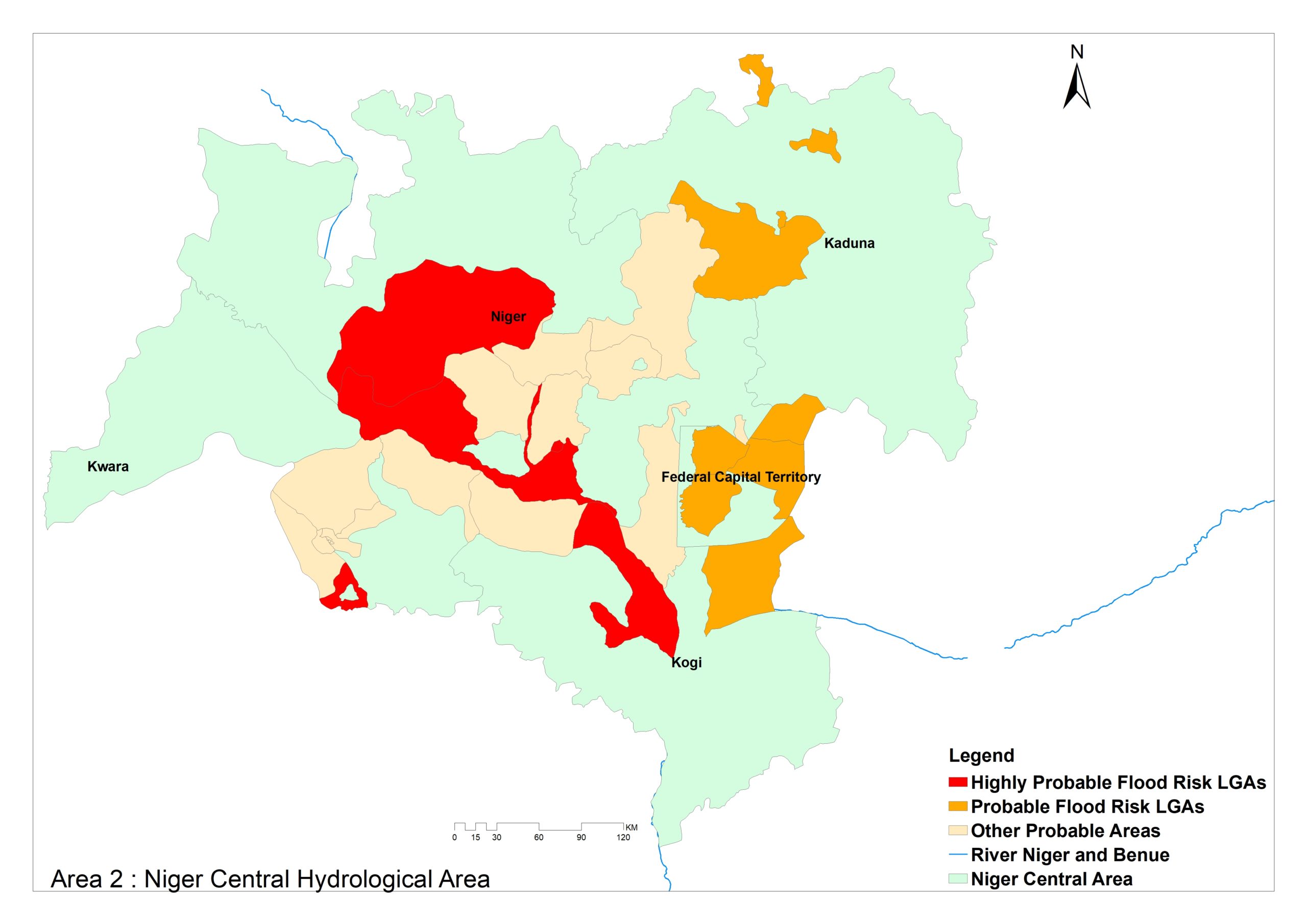
Area 2 – Niger Central covers Niger, Kwara, Kaduna and parts of Kogi state and FCT.
The highly probable flood risk LGAs are Kogi (Lokoja), Kwara (Oyun) and Niger (Bida, Mokwa, Mashegu).
The probable flood risk LGAs are FCT (Gwagwalada, Kwali, AMAC, Bwari) , Kaduna (Zaria, Kaduna North and Chikun), Katsina (Sabuwa, Funtua) and Kogi (Kotonkarife).
Others are Kwara (Ilorin West, Pategi, Edu, Asa, Moro, Ilorin East, Ilorin South) and Niger (Suleja, Gbako, Shiroro, Bosso, Wushishi, Lavun and Lapai).
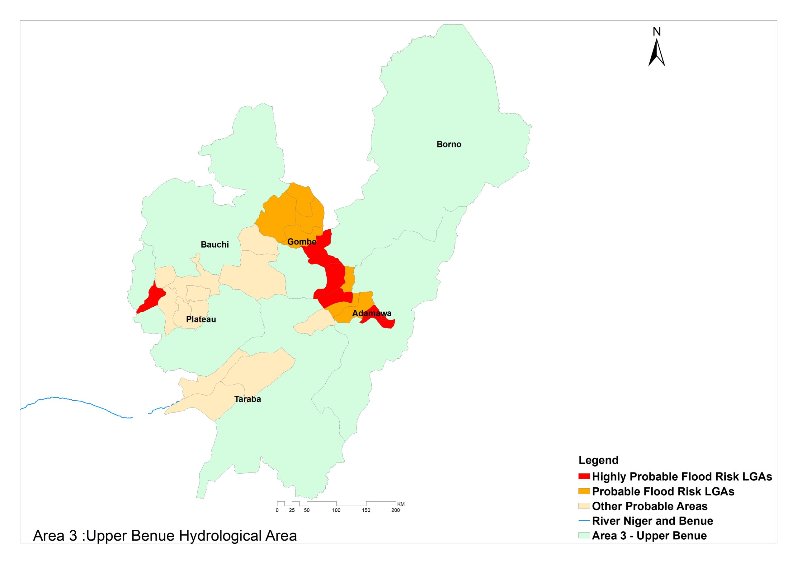
Area 3 – Upper Benue comprises Adamawa, Taraba, Gombe, Bauchi and parts of Plateau and Borno states.
Its major rivers are Benue, Gongola, Taraba, Donga, Faro and Mayo-Kebbi.
The highly probable flood risk LGAs are Adamawa (Yola North, Yola South, Lamurde), Gombe (Balanga, Yamaltu/Deba) and Plateau (Barkn Ladi).
The probable flood risk LGAs are Adamawa (Numan, Guyuk, Demsa) Gombe, Balanga, Dukku, Funakaye, Gombe, Kwami and Nafada).
Others are Plateau (Pankshin, Jos East, Kanke, Mangu), Taraba (Gassol, Ibi, Lau, Wukai) and Bauchi (Alkaleri, Bauchi, Tafawa Balewa, Kirfi and Bogora).
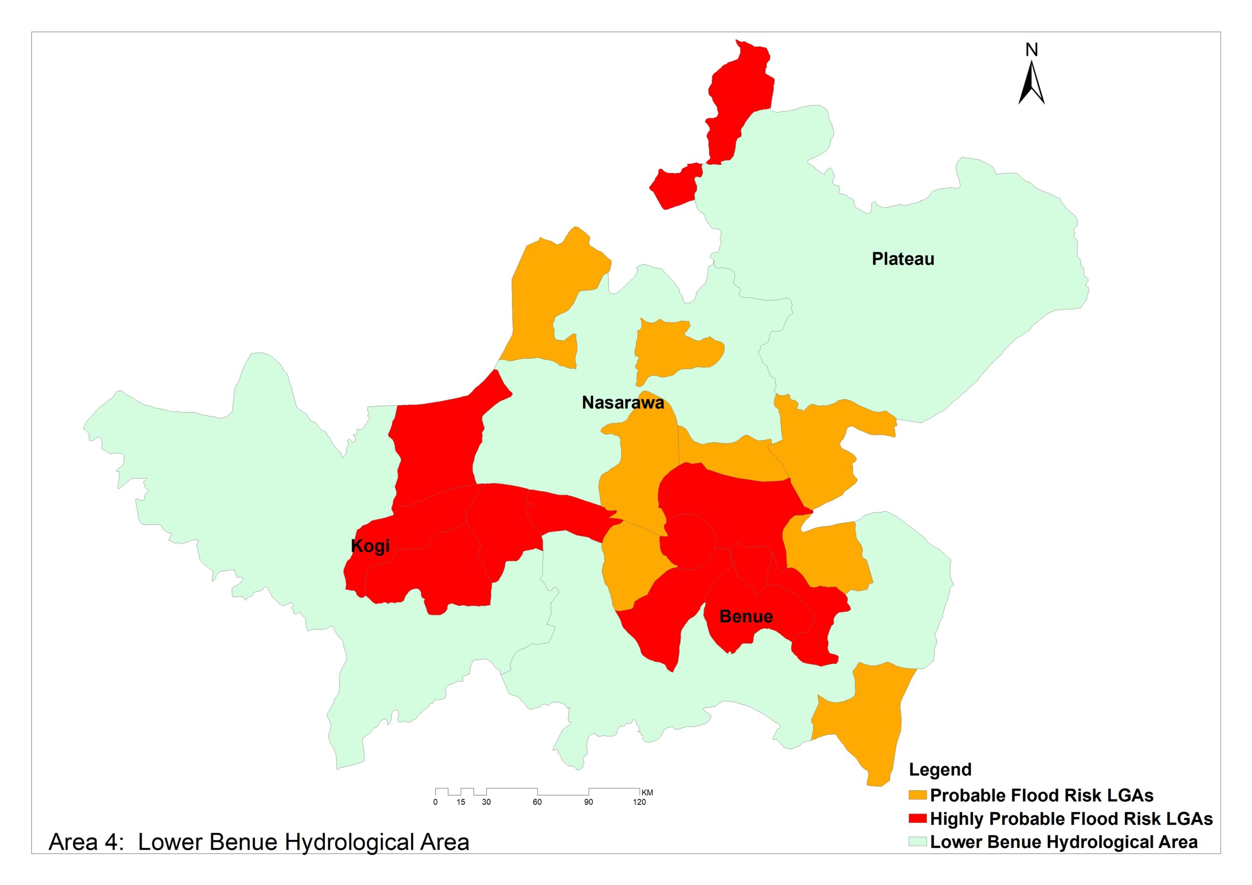
Area 4 – Lower Benue covers Plateau, Nasarawa, Benue and parts of Kogi and Kaduna State.
Highly probable flood risks LGAs are Benue (Buruku, Agatu, Gboko, Gwer East, Makurdi, Tarka, Guma), Kaduna (Kaura), Kogi (Bassa, Dekina, Omala) and Nasarawa (Nasarawa, Toto).
The probable Flood Risk LGAs are Benue (Gwer West, Logo, Kwande) and Nasarwaa (Nasarawa Egon, Keana, Doma, Karu and Awe).
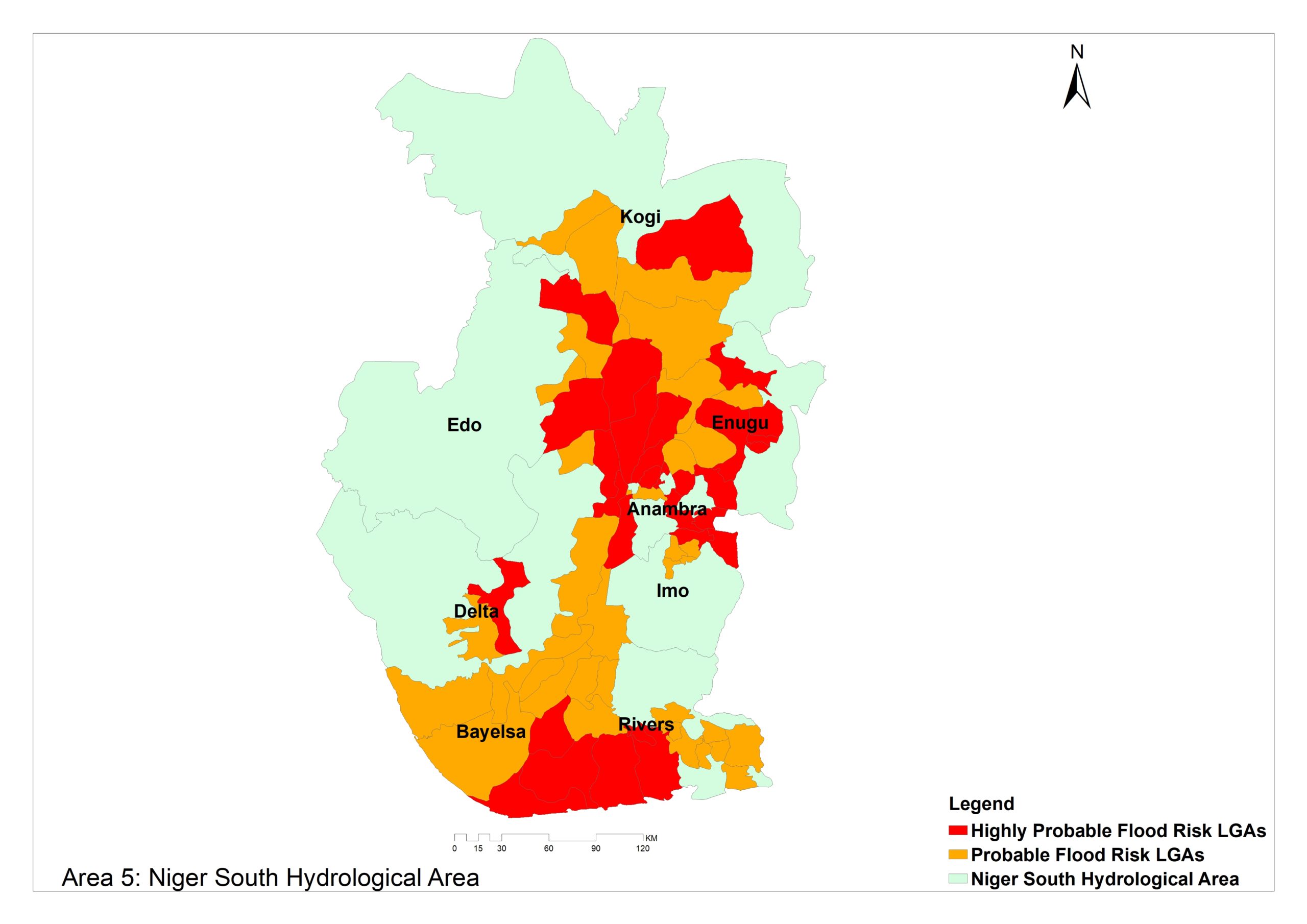
Area 5 – Niger South include Bayelsa, Delta, Edo, Anambra and parts of Kogi, Imo, Enugu and Rivers states.
The major rivers are Niger, Anambra, Ase, Orashi, Nun and Forcados.
The highly probable flood risk LGAs are Anambra (Ogbaru, Anaocha, Oyi, Anambra East, Onitsha North, Orumba South, Njikoka, Orumba North, Ayamelum, Aguata, Awka South, Anambra West and Dunukofia).
Bayelsa (Brass, Ogbia, Nembe), Delta (Ndokwa West, Aniocha North, Oshimili South, Ughelli North and Oshimili North) and Edo (Etsako East, Esan South, Esan East).
Others are Enugu (Enugu East, Udi, Nsukka, Enugu North, Enugu South, Oji River), Imo (Ideato North, Okigwe), Kogi (Dekina, Ibaji) and Rivers (Degema, Akuku Toru and Asari- Toru).
Probable flood risk LGAs are Anambra (Idemili North, Idemili South, Onitsha South and Awka North) and Bayelsa (Southern Ijaw, Ekeremor, Kolokuma/Opokuma, Yenagoa and Sagbama).
Others are Delta (Aniocha South, Patani, Ndokwa East and Ughelli South), Edo (Etsako Central, Esan North-East), Enugu (Igbo-Etiti, Ezeagu, Uzo-Uwani) and Imo (Ideato South, Njaba, Nkwerre and Orlu).
Kogi (Idah, Igalamela-Odolu, Ajaokuta, Ofu and Adavi), Rivers (Ahoada East, Ogba/Egbema/Ndoni, Andoni, Ogu Bolo, Ahoada West, Abua/Odual, Port Harcourt, Obio/Akpor, Gokana, Tai, Khana, Okrika).
Area 6 – Western Littoral comprises Lagos, Oyo, Ogun, Osun Edo and parts of Delta and Ekiti states.
It is drained by rivers Yewa, Osun, Shasha, Omi, Owena, Osse and Ossiomo.
Highly probable flood risk LGAs are Delta (Ughelli North, Ethiope West, Warri North), Lagos (Lagos Mainland, Mushin, Ibeju Lekki and Ikorodu), Ogun (Abeokuta South, Ogun Waterside and Ijebu East) and Osun (Ila).
The probable risk areas are Delta (Sapele, Warri South-West, Warri South, Ethiope East, Burutu, Ika North, Ika North-East, Ika South), Edo (Ikpoba-Okha, Oredo, Ovia North-East) and Ekiti (ijero, Irepodun/Ifelodun, Ado-Ekiti).
Others are Lagos (Lagos Island, Alimosho, Amuwo Odofin, Ikeja, Kosofe, Eti-Osa, Apapa, Ojo, Oshodi/Isolo, Agege, Ifako/Ijaye, Badagry, Surulere, Ajeromi/Ifelodun), Ogun (Ewekoro, Abeokuta North, Ode and Ifo) and Ondo (Irele, Ondo West, Ilaje, Akoko North West, Idanre, Ondo East, Ese Odo).
Osun (Ayedire, Ede North, Ede South, Egbedore, Ifelodun, Ilesha East, Ilesha West, Irepodun, Isokan, Iwo, Odo Otin, Ola-Oluwa, Olorunda, Orolu, Osogbo), Oyo (Ona ara, Lagelu, Oyo East, Kajola, Egbeda, Ogomosho South, Iseyin, Ibarapa North, Ibadan South West, Ibadan North West, and Ibadan South-East).

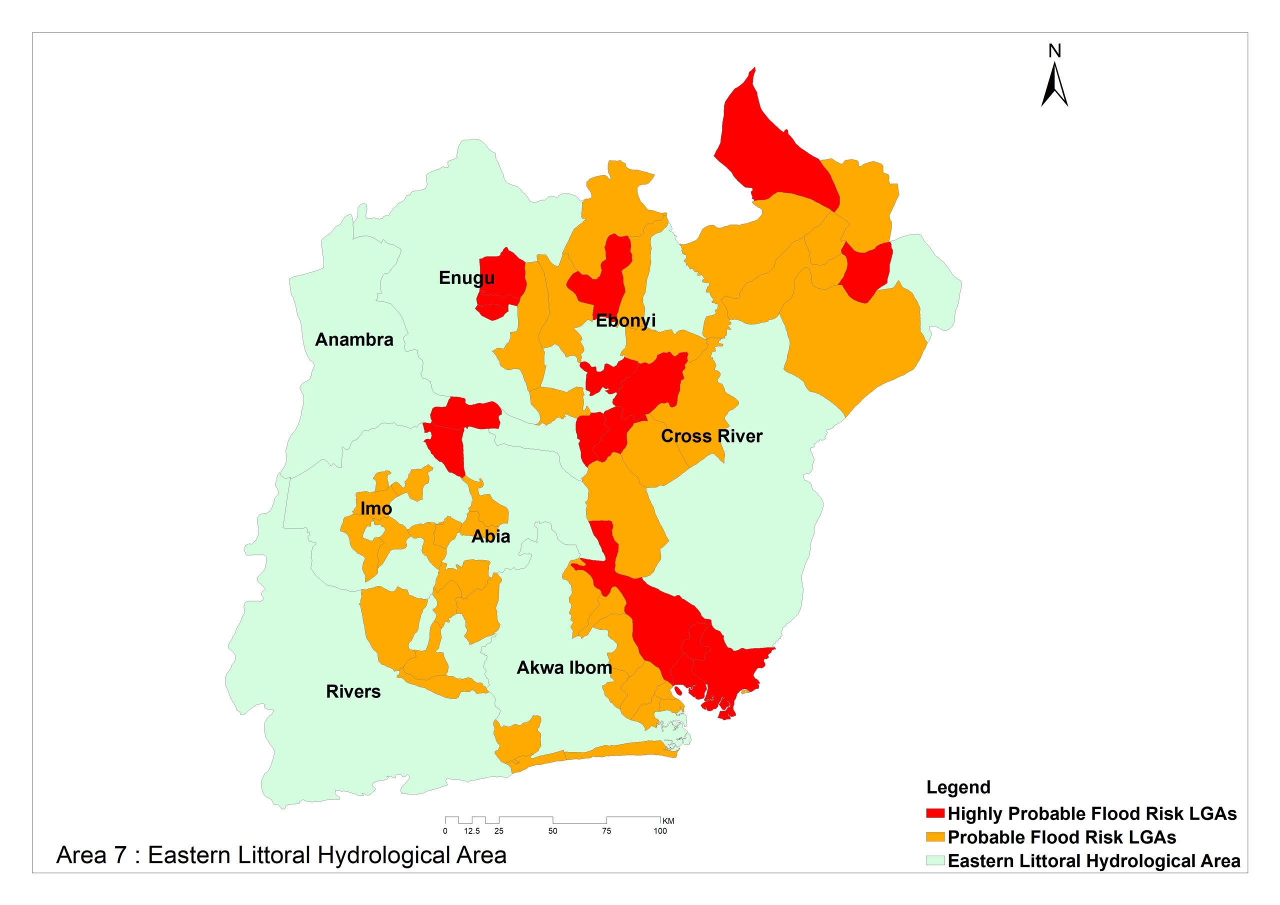
Area 7 – Eastern Littoral comprises Abia, Anambra, Imo, Enugu, Ebonyi, Cross River, Akwa ibom and Rivers States.
It is drained by Imo, Qua-Iboe, Calabar, Ivo, Asu, Cross River and Ebonyi rivers.
Highly probable areas include Abia (Umunneochi), Benue (Konshisha), Cross river (Calabar South, Calabar Municipal, Akpabuyo, Abi, Obudu and Odukpani), Ebonyi (Afikpo North, Ezza South, Ezza North, Ikwo, Ohaukwu), Enugu (Enugu East, Enugu North and Enugu South) and Imo (Okigwe).
Probable flood risk LGAs are Abia (Osisioma Ngwa, Obingwa, Umuahia South, Umuahia North, Ukwa West, Isiala-Ngwa North) and Akwa Ibom (Nsit Atai, Okobo, Mobo, Udung Uko, Oron, Eastern Obolo, Itu, Ikot Abasi, Ibiono Ibom, Uruan, Uyo, Ibeno, Urue Offong/Oruko).
Others are Benue (Ado, Vandeikya), Cross River (Yakurr, Obubra, Yala, Bakassi, Boki, Ogoja, Bekwarra, Biase), Ebonyi (Ebonyi, Ishielu, Ohaozara, Abakaliki), Enugu (Nkanu East), Imo (Owerri West, Owerri North, Mbatoli, Ezinihitte, Isu, Isiala Mbano, Aboh-Mbaise) and Rivers (Oyigbo, Etche).
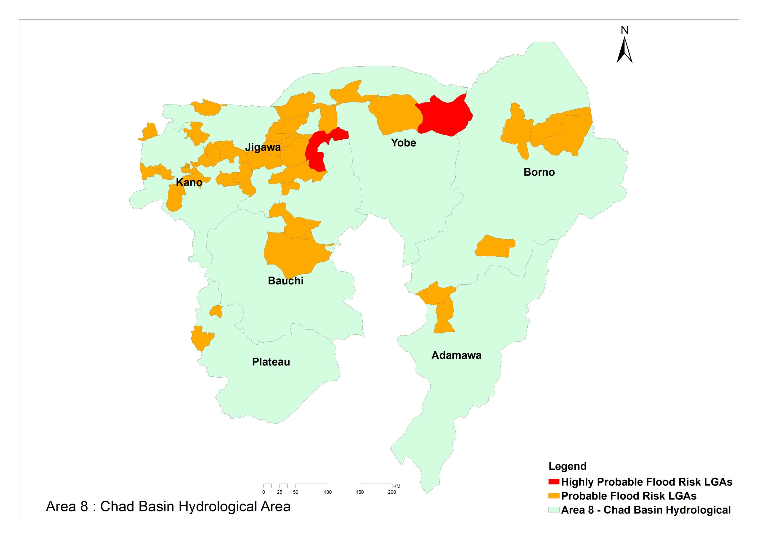
Area 8 – Chad Basin comprises Kano, Jigawa, Yobe, Borno, and parts of Bauchi, Plateau and Adamawa states.
Major rivers in the area are Hadeija, Jama’are, Komadugu-Yobe, Yedseram, Ngadda and Dingaiya.
Highly probable flood risks LGAs are Bauchi (Zaki) and Yobe (Geidam).
The probable flood risk areas are Bauchi (Jama’are, Itas/Gadau, Shira, Ganjuwa), Borno (Marte, Maiduguri, Abadam, Mafa and Kukawa) and Jigawa (Kaugama, Taura, Guri, Gwaram, Dutse, Auyo, Miga, Malam, Maduri, Ringim, Birniwa, Jahun, Kafin Hausa).
Kano (Taurauni, Garum Mallam, Rimin Gado, Gaya, Gezawa, Gwale, Shanono, Gabasawa, Gwarzo, Ungongo, Warawa, Dawakin, kudu, Dambatta, Bebeji, Kabo, Wudil, Kura, Nasarawa, Kano Municipal, Kumbotso).
Others are Katsina (Kusada, Zango and Baure), Plateau (Jos North) and Yobe (Barde, Borsari, Karasuwa, Yunusari).
Support Our Journalism
There are millions of ordinary people affected by conflict in Africa whose stories are missing in the mainstream media. HumAngle is determined to tell those challenging and under-reported stories, hoping that the people impacted by these conflicts will find the safety and security they deserve.
To ensure that we continue to provide public service coverage, we have a small favour to ask you. We want you to be part of our journalistic endeavour by contributing a token to us.
Your donation will further promote a robust, free, and independent media.
Donate HereStay Closer To The Stories That Matter