Some Communities In Nigeria’s Capital Have Become Increasingly Unsafe. Satellite Data Explains It
Nigeria’s Federal Capital Territory is the most protected place in the country. In the past weeks, there have been several attacks and abductions in suburban communities. We used satellite data to analyse the infiltration and retreat of armed groups.
The Federal Capital Territory (FCT) of Nigeria is the most protected place in the country.
Priority areas like Asokoro and Maitama are concentrated with security infrastructure to protect the seat of power, particularly around the Aso Presidential Villa, which houses key establishments and the presidential residence with an array of security headquarters and checkpoints that create an impenetrable defence against potential threats. However, as one moves away from this centralised security hub, these privileges become thinner.
Approximately 30 kilometres north of these high-security zones lie suburban communities situated around the blurry boundary lines between neighbouring states. These areas, lacking sharp administrative divides, receive minimal security attention, leaving them susceptible to security breaches. The sparse presence of security forces in these isolated border communities raises concerns about response times and recovery efforts.
Interactive: Security Hub (Green) and Besieged Suburbia (Red)
In recent weeks, a disturbing pattern of abductions and attacks has unfolded in various areas on this axis. On the first day of the year, unidentified gunmen targeted Barangoni, in Bwari ward, a location merely 3 kilometres from the border. A vigilante member was shot and injured while three individuals were forcefully abducted.
The following day, terrorists infiltrated the Zuma area within the Bwari suburbs, abducting seven family members, during which two policemen sustained gunshot injuries that led to their deaths, and a civilian lost his life instantly. Shockingly, just over a week later, one of the kidnapped victims was killed due to the family’s inability to meet the ransom deadline.
Five days after the Zuma abduction, in a settlement situated approximately 14 kilometres away, gunmen struck again. This time, ten residents of the Sagwari Layout Estate in Dutse were abducted, and three victims lost their lives as a warning to their relatives who were negotiating ransom. Four days later, the trend continued. Gunmen believed to have traversed the forests linking the Kawu community with Niger and Kaduna states, launched a large-scale attack, abducting a number of residents, including the son of the district head, and adding to the growing list of victims in this unsettling trend.
Security seems to be unable to keep up with the cases as they mount. More hostages are being killed, and these communities remain vulnerable to further attacks.
Geographic Vulnerabilities
These vulnerable localities, which are along the indistinguishable interstate boundary between the Federal Capital, Niger and Kaduna states, present a complex situation, as there is a security vacuum in these places. The locations are also surrounded by hills and forests, making it easier for criminal elements to enter and retreat unchecked.
The Bwari suburbia are typically sparsely distributed, including farming and hunting communities situated amid towering hills, vast forest landscapes, and mountain ranges. The residents of these areas are predominantly rural or suburban dwellers. Many depend on the lands for small-scale farming, while the wilderness provides a source of wildlife for hunting. For the majority of inhabitants, these locales offer a more affordable alternative in terms of rent and cost of living. Some individuals commute from these outskirts into the city to their jobs and business ventures.
However, the trend of insecurity has caused residents to fear for their safety. They claim these kidnappers enter their communities, usually unchallenged by security forces and head for the hills with captives, and into the nearby forests of Niger state.
Cross-Border Threats
Hilly areas along large interstate wilderness terrain, including Bwari bushes and Zuma hills, serve as entry points and retreat avenues for criminals. The landscape facilitates not only the execution of raids but also the elusive escape, allowing them to navigate unseen through vast wilderness and adjacent farmlands.
Interactive: Cross-border threats.
In Zuma, reports indicate that the kidnappers targeted specific residents and managed to escape with captives, even in the face of security intervention. They may have originated from a concealed launchpad in the bushes, behind the hills, or from isolated settlements scattered within the forest environs, making it challenging to track their movements, especially with limited intelligence on imminent assaults. Local accounts suggest that these groups established camps in the hills, using them as bases to plan and execute their raids.
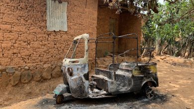
The terrain also facilitates their retreat, with the same cover enabling them to navigate undetected. Recent incidents of abductions and attacks in these outlying areas of Bwari highlight the escalating threats. From Barangoni to Zuma, Dutse to Kawu, these suburbs have become hotspots for criminal activities, prompting locals to flee the insecurity-ridden zones.
Interactive: Nearest security formations and estimated response time
Local police responses, like the Bwari Police Station, often fall short due to an intelligence gap, delayed reporting, and most importantly, inadequate response strategy. Even when informed on time, they are hardly proven capable of handling the situation. Despite Zuma being within ten minutes, assailants made a clean break without any reported concerns about a security perimeter or manhunt.
A number of communities in these regions are also confronted with similar threats. The government, under the G7 security measures — which is an interstate collaborative effort to share security and intelligence insights amongst cross-border states with the federal capital — aims to strengthen task force operations for the FCT and surrounding states. This involves tracking down terror camps and cells around these bushy areas. Despite this, recent incidents suggest a stronger presence of these terror groups as residents of neighbouring communities relocate to avoid falling victim.
Geographically, they do not have significant advantages over the communities that have already fallen victim to these incidents. Some of these at-risk communities may include Kuchiko, Kato, Ija Gwari, and locations near the lower Usuma Dam.
Interactive: At-risk communities within approximately 900 square kilometres of danger zone [Marked area].
Following the abductions in the Bwari Area Council, the Police headquarters promised to initiate a plan to counter attacks and rescue the victims.
“The NPF is actively engaging and contacting individuals crucial to the rescue operations and investigation. The objective is not only to bring perpetrators to justice but also to intensify efforts in rescue operations for victims still in captivity,” the force spokesman assured.
Security has also been heightened in these areas. This is typical of the Nigerian response to these kinds of incidents; these measures are often temporary, and soon after personnel and installation are removed, the crisis returns again. As rescue efforts continue, it is also important to note that the threat still remains, and authorities should establish proper measures to protect these suburban communities and establish a sense of control over the ungoverned forest landscape near them.
Summary not available.
Support Our Journalism
There are millions of ordinary people affected by conflict in Africa whose stories are missing in the mainstream media. HumAngle is determined to tell those challenging and under-reported stories, hoping that the people impacted by these conflicts will find the safety and security they deserve.
To ensure that we continue to provide public service coverage, we have a small favour to ask you. We want you to be part of our journalistic endeavour by contributing a token to us.
Your donation will further promote a robust, free, and independent media.
Donate HereStay Closer To The Stories That Matter