Satellite Analysis: Uncontrolled Development Increasing Flood Risk In Kano
Kano needs to adopt a sustainable approach to urban development and management of the environment to mitigate the impacts of flood risk and climate variability.
Kano, Nigeria’s second most populous city with a population of over four million, has many problems, including uncontrolled development. With the help of satellite images, HumAngle examines the city’s vulnerability to extreme rainfall, which climate change could amplify.
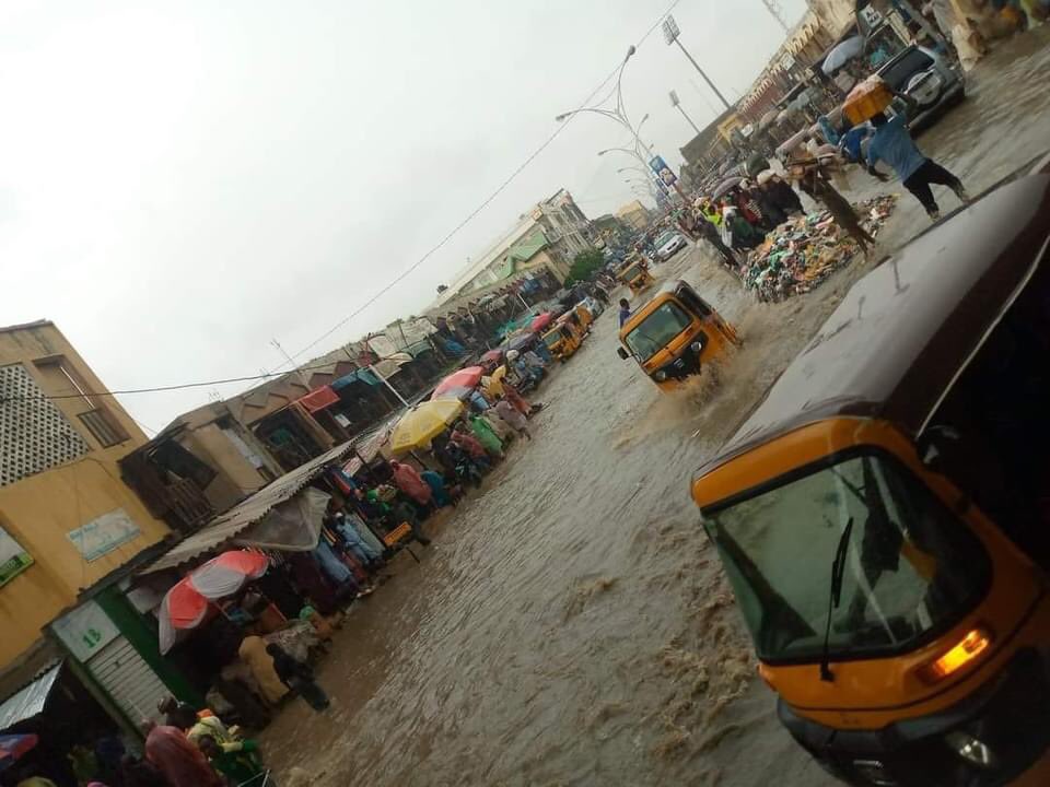
The adverse effects of the ancient city’s unrestrained urbanisation and inefficient flood control systems were evident last month when torrential rainfall submerged neighbourhoods, including the office of the State’s Emergency Management Agency and the famous Kantin Kwari market. In response to the disaster, the State Government constituted a technical committee to investigate the cause.
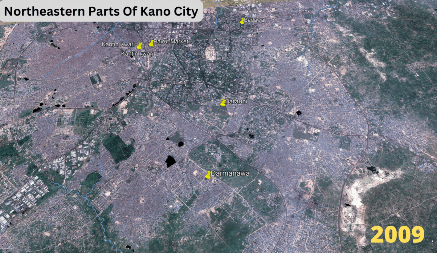
Over the past decades, Kano has continued to expand, outgrowing the original city walls and building on its legacy as a commercial hub in northern Nigeria. However, the rapid urbanisation in the northeastern parts of Kano City has also led to the depletion of green areas replaced by structures for local markets and other economic activities.
Areas such as Badawa, Beirut Market, Darmanawa, Tarauni, and Kantin Kwari market, which recently witnessed severe flooding, are located on this axis. This expansion has not spared critical natural water pathways and brought populations and properties within floodplains.
The water channels also pass through households and business areas that are filled with open refuse dumps, which obstruct discharge into lakes and rivers outside the city. These factors, alongside insufficient and inefficient drainage infrastructure, have increased the city’s risk of extreme weather events.
The National Hydrological Services Agency flood outlook published in May had categorised Kano as one of the highly probable flood risk States. The state records almost 1000 mm of annual rainfall on average, making it one of the northern states with the highest amount of precipitation yearly.
In June, flooding destroyed about 3,000 houses after sweeping through six local government areas of Rano, Kibiya, Doguwa, Dambatta, Kiru, and Tsanyawa in Kano state. A few months later, the National Emergency Management Agency disclosed that 14,496 farmlands in Warawa, Wudil, Bebeji, Rano, and Dawakin Kudu were destroyed by flood in five Local Government Areas.
The flooding in the metropolitan city in August reportedly caused the loss of goods worth over N200 million in Kanti Kwari market, located in the eastern part of the state. According to a Nigerian news outlet Daily Trust, traders in the affected market complained that indiscriminate buildings and structures on drainage, in addition to construction, had made the market susceptible to flooding. Newly constructed shops were also said to have blocked more extensive waterways that enabled better water flow.
What Satellite Data Says
Satellite data of Kano city highlights the scale of the problem caused. With the growing population in the state, the demand for residential and business land has caused the depletion of open land and drainage networks especially near commercial areas. The satellites also show how green areas and water bodies are not spared in this development culture, weakening the capability of the nature-based systems to protect the city against environmental disasters.
HumAngle’s assessment of the drainage network of Kano showed that flooding was inevitable and remains a significant public health and safety concern.
An example of this nexus between geography and disaster risk in the State is the situation in the Fagge local government of Kano and its its contribution to the disastrous flood in the Kanti Kwari market. The buildings in Fagge are compact, hardly spaced out from each other, while at the same time, progressing into waterways where they have shrunk the widths of the natural drainage channels which pass through the town.
The vulnerability of the market is also linked to an open channel that vanishes underground just at the edge of the Kofar Mata Road, giving the running water fewer options than to cross over the road and into the opposite environment – with the market area, unfortunately, positioned to receive the excess water.
The residents who feel the brunt of the practice are those located on the lower axis of the drains or situated downstream of the water channels. This sewage-ladened water overflowing also poses significant health and water contamination risks.
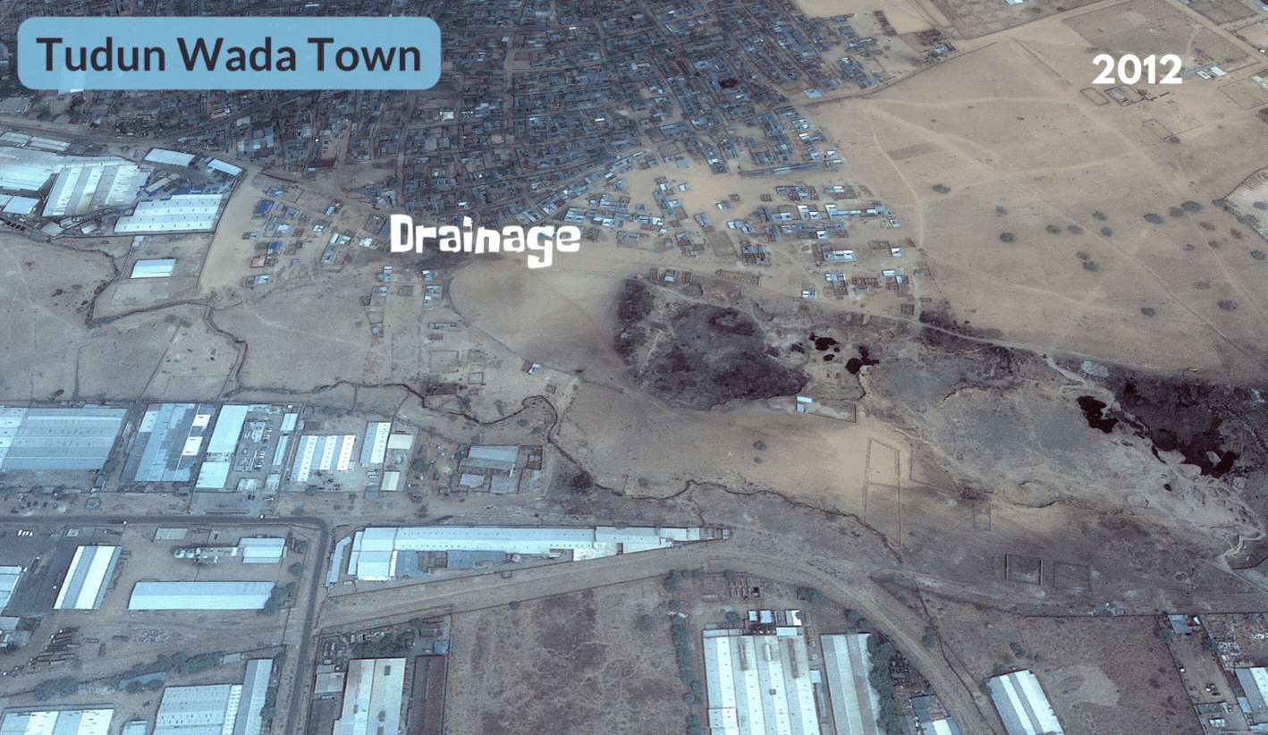
Satellite images show densely situated buildings formed over the years. The buildings have covered the drainage path as numerous structures standing only a few meters higher in elevation than the nearby flowing water basin.
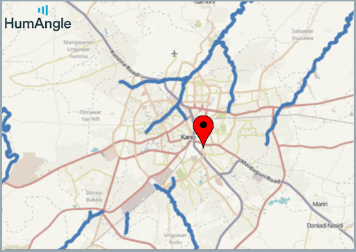
These developments put both lives and properties in jeopardy. An example is a risk-prone area in the satellite image above, Tudun Wada, a place situated downstream of the Jakara River at the edge of the City.
Depleting lakes
The depletion of lakes or ponds in some parts of the city contributes to the threat of runoff during heavy rainfall. The Kofar Dan Agundi lakes in central Kano which serve as flood control for its surrounding environments, have experienced large-scale incursion that diminished their capacity to be effective as a sponge.
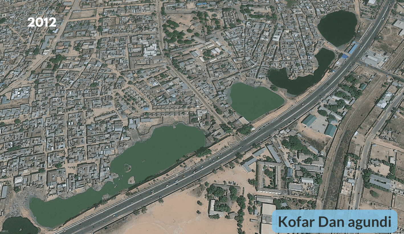
Over the years, the lakes have been shrinking, extending city limits to the lake basins and bringing along a growing population increasingly seeking housing and commercial properties.
A member of the institute of architects, Khalifa Rabiu Tahir, in an interview, says Kano is relatively like a plain when it rains; the water moves into the surrounding ponds, which serve as natural collectors. He attributes the recent flooding to distortion of natural reservoirs, which led to overflow into the nearby areas and poor drainage and urban planning in the city.
Mitigating the increasing flood risk
The threat of flooding could continue to be a challenge for communities and businesses in flash points, especially around reservoirs and waterways, except if authorities invest in short and long-term measures to address the vulnerabilities and strengthen resilience.
Khalifa also says the solution to the problem would involve the sustainable use of natural resources, proper drainage construction and urban planning, and addressing the encroachment into reservoirs.
In 2016, a team of researchers from Ahmadu Bello University, Zaria in Northern Nigeria, studied Fagge local government, where they noted the need for constructing additional drainage channels and rehabilitation of the existing ones. The study suggested that the eastern part of the area was the most at risk of flood due to its drainage network and geographic profile relative to the streams.
Kantin Kwari market and the four other recently flooded localities happen to be situated in this eastern region.
In early September, the state began the demolition of permanent and temporary structures built on flood plains in the Kantin Kwari. The Commissioner of Environment, Kabiru Ibrahim Getso, was quoted to have said that the government had conducted a physical assessment and found out that the flooding occurred as a result of indiscriminate dumping of refuse in drains, buildup on flood plains alongside the topography of the area, and the effect of climate change.
The capacity of authorities in Kano to mitigate the flood risk would require a multidimensional approach and investment to enhance and protect essential channels for evacuating excess water. Alongside the provision of relevant infrastructure, public education, and environmental regulation.
Support Our Journalism
There are millions of ordinary people affected by conflict in Africa whose stories are missing in the mainstream media. HumAngle is determined to tell those challenging and under-reported stories, hoping that the people impacted by these conflicts will find the safety and security they deserve.
To ensure that we continue to provide public service coverage, we have a small favour to ask you. We want you to be part of our journalistic endeavour by contributing a token to us.
Your donation will further promote a robust, free, and independent media.
Donate HereStay Closer To The Stories That Matter