Nigerians Brace For More Flooding As Rainy Season Heightens
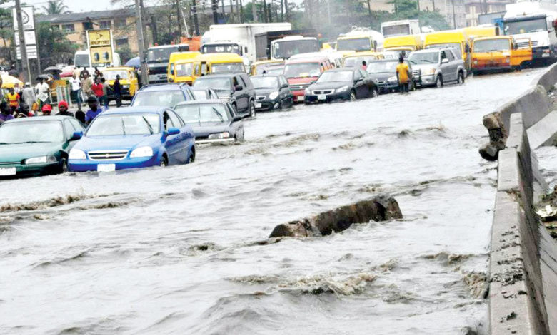
On June 18, 2020, different parts of Lagos State, Nigeria’s commercial capital, were submerged by floodwater following torrential rainfall and overflowing drains.
Residential areas and roads in Lagos Mainland and Lagos Island were flooded leading to the collapse of some structures and long hours of gridlocks on the roads.
City residents shared videos and photos online of flood scenes, including heaps of plastic waste left behind by the receding water.
According to Lagos State Emergency Management Agency, 20 families were displaced at Orile-Agege area of the metropolis as a result of the flooding.
Temple Oraeki, the Nigeria Country Director of Hope Spring Water Charity Foundation and Program Coordinator of Nigeria Young Water Professionals, said advance warning gives ample time for people to prepare and plan for flood incidence. The common routine of waiting till the rains come is neither effective nor sustainable.
Lagos is among the states expected to battle coastal and urban flooding, according to the annual flood warning released by Nigeria Hydrological Services Agency (NIHSA).
In its annual flood outlook for 2020, NIHSA stated that 102 local governments areas in 28 states fell within the highly probable flood risk areas and that 284 local government areas in 36 states and Federal Capital Territory were within the moderately probable flood risk areas.
The agency said coastal states such as Rivers, Cross River, Delta, Lagos, Ondo and Bayelsa were expected to experience coastal flooding due to tidal surge and climate change-related sea level which would impact fishing, habitation and coastal transportation.
“Flash and urban flood are also expected to occur in some locations such as Birnin Kebbi, Sokoto, Lokoja, Kaduna, Suleja, Gombe, Yola, Makurdi, Abuja, Lagos, Asaba, Port Harcourt, Yenagoa, Ibadan, Abeokuta, Benin city, Kano and major cities with poor drainages,” the agency stated.
Flooding is a reoccurring environmental disaster across Nigeria. In 2012, unprecedented flooding led to the displacement of 387, 153 people, 363 deaths and caused 16.9 billion dollars to manage. In 2019, flooding caused 126 deaths and displaced over 48, 000 people in 180 local government areas.
Comparative hydrographs for the agency’s hydrological measuring station downstream of the confluence of rivers Niger and Benue in Lokoja, for 2012, 2018 and 2019 showed that flood level starting from May 22, 2019, exceeded the corresponding values in 2012 and 2018.
NIHSA in 2020 flood outlook stated that the stimulate hydrographs of gauging stations at Tiga, Kainji, Ologbo, Kende, Geidam, Ikom, Lokoja, Malabu, Okitipupa, Onitsha, Siluko, Zungeru, Abeokuta, Dadin Kowa, Hadieja, Kafin Gana, Katsina Markudi, Shiroro and others showed gradual increments in flood discharge
However, the predicted probable flood areal coverage in 2020 was expected to be lower than that of 2019, according to the agency.
The soil moisture of low plains during peak rainy season, topography, poor drainage and extreme weather conditions related to climate change, dam overflow outside the country, especially Lagdo dam in Cameroon, are described as some of the causes of flood.
In 2019, the release of water from Lagdo dam on the Upper Benue River basin led to flooding in Adamawa and red alert notice in downstream states of Rivers, Bayelsa, Edo, Kogi, Taraba, Benue and Kogi.
According to experts, flood mitigation is important to protect lives and livelihoods.
Oraeki told HumAngle that proper mapping of flood plains and enforcing laws that deterred people from building on floodplains was necessary.
“If flood plains are properly mapped out in Nigeria and residents properly advised on risks of constructions on such sites, we would be reducing flooding incidents and saving more lives,” he said.
Onyeukwu Nnadozie a geospatial analyst, shared similar thoughts on the importance of mapping for flood mitigation and said, “flood disaster can only be successful when detailed geospatial knowledge is obtained about a geographic area.”
Nnadozie said that vulnerability mapping along river lines could be conducted to know population size to be evacuated as well as properties that would be affected before a flood happened.
“Medium altitude unmanned aerial vehicles (UAV) can be used to monitor flooding in real-time, warn nearby communities of impending flooding for evacuation readiness and at the same time used to conduct high-resolution aerial mapping of flooded places.
“These images can, in turn, be used to guide evacuation teams and perform post-flooding analysis,” he said.
The absence and blockage of the drainages also increase flood risk in urban areas, Oraeke said, and urged relevant authorities to pay more attention to waste management in Nigeria.
“Putting in place a holistic waste management system alongside sensitisation of citizens on proper waste management would be highly helpful in addressing frequent flooding incidents; these should also be backed by laws in respective states that deter people from indiscriminate waste disposal,: Oraeki said.
He stressed the need for climate action to mitigate climate change induced extreme weather conditions resulting in excessive rainfall.
” There’s need for more sensitisation on the simple climate actions that individuals can tackle climate change, such as reducing greenhouse gas emissions from the burning of fossil fuel, encouraging tree planting and discouraging cutting down of trees”.
Jibril Abdulmumin Ibrahim, an environmentalist, said natural flood control systems were important.
He said the conversion of forests to farmland, building on wetlands and floodplains due to urbanisation was affecting natural flood mitigation and control systems.
Support Our Journalism
There are millions of ordinary people affected by conflict in Africa whose stories are missing in the mainstream media. HumAngle is determined to tell those challenging and under-reported stories, hoping that the people impacted by these conflicts will find the safety and security they deserve.
To ensure that we continue to provide public service coverage, we have a small favour to ask you. We want you to be part of our journalistic endeavour by contributing a token to us.
Your donation will further promote a robust, free, and independent media.
Donate HereStay Closer To The Stories That Matter