Is Dredging Of Rivers One Way Of Mitigating Floods Across Nigeria? To An Extent
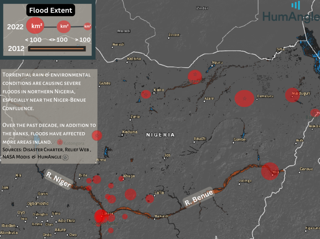
More than half of Nigeria’s states are currently experiencing, or at risk of severe river floods since Rivers Niger and Benue broke their banks. Some states have adopted dredging and widening rivers and waterways in coastal communities to mitigate this. HumAngle analyses this approach.
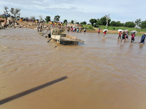
Several Nigerian cities have been battling with the worst flooding in a decade from the onset of the rainy season in June. It has been reported that over 500 people have lost their lives, and thousands have been displaced. Millions of properties have also been lost as farmers suffer heavy losses.
On Friday, Sept. 16, the NIHSA had warned that the overflowing of Rivers Niger and Benue could cause massive flooding in 14 states across the country. Days later, several communities in Kogi, a state in the north central region, started to witness unprecedented flooding after the two rivers broke banks. The disaster has become quite severe in the state as residents, as well as travellers, have been stranded for days, resulting in worsening humanitarian crises.
River dredging: A case study of Nigeria’s Osun State
River dredging is not a particularly new concept in Nigeria. Since 2016, Osun state, Southwest Nigeria, has implemented a river dredging project to mitigate flooding in the state, especially in the capital city of Osogbo, which had been affected by flooding during the rainy season.
HumAngle spoke to Hamza Yunusa, a hydrogeologist, on the causes of river floods and how dredging might forestall it. Although heavier rainfalls are a factor, there are several other things that could cause rivers to be incapable of holding the water that flows through them. Yunusa stated sediments depositing on river beds, collapsed dams, and deforestation are those factors.
River dredging could reduce river floods by removing these sediments and debris from river beds to improve the capacity of the rivers to hold and absorb more water. “Oftentimes, rivers break their banks and overflow when the river bed is not deep enough,” Yunusa explained.
In a report, Tope Awosiji, the engineer in charge of the dredging project in the state that year, listed Gbonmi, Alie Agbede, Fiwasaye, Obatede, Old Garage, Alekuwodo and Ita-Olokan, all in Osogbo, as areas of focus for the project.
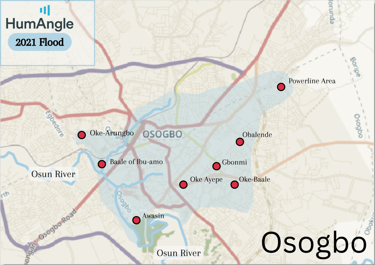
An analysis of media reports showed that the project was not sustained for the subsequent years. In fact, in 2021, Daily Post reported how several residents of Osogbo lost their lives during a heavy downpour which lasted about four hours and flooded the city. The report revealed that at least three corpses were found during that incident, while several properties were damaged, displacing residents of the areas affected.
By Oct. 2021, the Osun State Government urged the Federal Government to rehabilitate the waterways in the state to deter repeated flooding. This call was made after a flooding disaster wreaked some areas of Osogbo, including Ilesa, a Local Government Area of the state.
HumAngle’s geospatial assessment of the level of flooding across Osogbo found that there were less flooding disasters in 2016 when the dredging project was ongoing compared to 2021 when it had stopped. The below imagery presents a comparative map of Osogbo’s flooded areas in 2016 and 2021.
However, this year, the Osun state has been reported to not record any flooding disasters for the first time in four years. In a report published by The Point, it was stated that residents of Osun have not, so far, and may not witness any flooding disaster as the rainy season is nearing its end this year. The report noted that the state government had commenced dredging of waterways and rivers after warning signals were released.
Kaduna replicates
Kaduna State, Northwestern Nigeria, has also implemented similar efforts to mitigate flooding disasters around the state especially in communities where the Kaduna River, which is a part of River Niger, runs through the state including its capital city.
Hafiz Bayero, the commissioner of the Kaduna Capital Territory (KCTA), told HumAngle that river floods was the baseline for the river dredging project in Kaduna which commenced in July, and is still ongoing especially in districts and communities that were worst hit by the flooding last year.
He listed Unguwan Dosa, Malali, Badarawa, K.K, Millenium City, Hayin DanMani, Gamji Park, Nasarawa and other communities affected, explaining that after extensive study it was discovered that these areas had parts of the Kaduna River’s tributaries.
In the state, the dredging project does not only desilt the river, it also deepens the river’s bed and expands its width so that the waterways would be able to hold more volume of water as rain falls to avoid flood disasters.
Bayero says that the state has experienced lesser flooding this year due to this ongoing project, “yes, we experienced some flooding but not as bad as last year. The flooding this year affected two areas; Kigo Road and Unguwan Dosa.”
Using satellite data, HumAngle assessed the depth of River Kaduna around the recently flooded Kigo road. The investigation revealed that the sediments at the bottom of the river had risen by about 9 per cent in recent times. This suggests that there were deeper channels of the river in 2019 than there are in 2022.
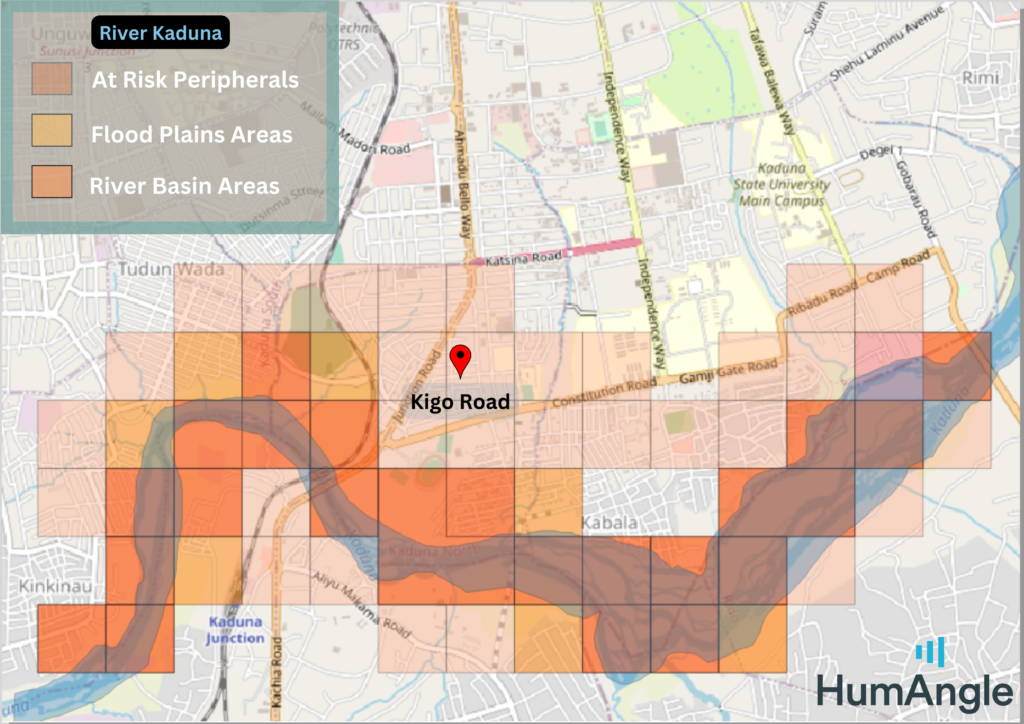
The above imagery confirmed that Kigo road along with parts of Bahama road, Gamji Park, Katsina road, Kabala, Kaduna Junction, Makama road, and Tudun Wada, which are some of the areas the Kaduna Government is implementing the dredging project have been at increasing risk due to their proximity to the river.
From the map, the threat of flood enhances after each downpour and as the under water sediments rises, the hazard areas [Coloured Markers] levels with the city. This easily allows the flow of water into these towns and environs. Like Kigo Road, some of these areas have already experienced flooding recently.
However, Yunusu, the hydrogeologist, revealed that river dredging is not a long-term solution to flooding especially in Nigeria where poor urban planning efforts, poor drainage systems, and indiscriminate dumping of waste highly contributes to the disaster.
He states that, “the best way to stop flooding would be to improve our urban planning efforts, or rather to enforce it. Most floods in Nigeria are due to negligence on the part of development control authorities in states and that of the populace.”
He added that building a reservoir in the flood channel to capture large volumes of water before it collects momentum, and using vegetation to arrest river flow velocity would significantly reduce river floods.
River dredging is still essential, he says, because it decreases negative environmental impacts in coastal communities by clearing and preventing waste amassing in one area. “If we don’t dredge rivers, the water won’t flow properly and could begin to harbour waste which could be harmful to the environment. Areas that need dredging often have fewer wildlife, bad water quality and a pungent smell,” Yunusa noted.
Support Our Journalism
There are millions of ordinary people affected by conflict in Africa whose stories are missing in the mainstream media. HumAngle is determined to tell those challenging and under-reported stories, hoping that the people impacted by these conflicts will find the safety and security they deserve.
To ensure that we continue to provide public service coverage, we have a small favour to ask you. We want you to be part of our journalistic endeavour by contributing a token to us.
Your donation will further promote a robust, free, and independent media.
Donate HereStay Closer To The Stories That Matter